Hi, I'm Mark
Robotics perception engineer • SLAM, 3D mapping, and sensor fusion
I've spent the last decade or so building autonomous robots, from research platforms in New Zealand to systems now deployed commercially in Japan, where I'm a permanent resident and speak conversational Japanese. My work runs from perception software through to mechanical design and embedded hardware.
Current Work
Robotics Software Engineer
Since 2018, I've developed perception and mapping software at SEQSENSE in Tokyo for autonomous robots: SQ-2, a security robot deployed as a fleet across airports, offices, and public buildings in Japan, and FORRO, a delivery robot co-developed with Kawasaki Heavy Industries.
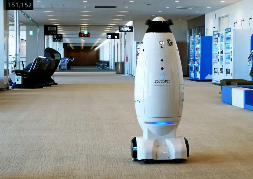
Both robots use a rotating turntable with three 2D LiDARs for navigation and wide-angle cameras for 360-degree vision. They transmit real-time data to a web platform for monitoring and can autonomously dock for charging and operate elevators for multi-floor operations.
My work spans online lidar-based 3D mapping that runs in real time on desktop, in the cloud, and on the robot itself; 3D object detection and tracking from lidar and camera, with detection models for people and other robots trained in PyTorch and OpenVINO; and Gazebo simulation that mirrors robot behaviour, with robot models built from CAD. The video shows a prototype interface I developed for real-time SLAM mapping using ROS and C++. Users could view maps as they were built, with scan quality indicated in green. The interface was designed for tablet/smartphone display mounted to a PlayStation controller.
Agricultural Robotics R&D
Kiwifruit Automation Project
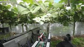
From 2015 to 2018, as a post-doctoral researcher with the University of Waikato and later the University of Auckland, I worked on robotic systems for kiwifruit operations. At Waikato I led a team of six to ten engineers designing and building the platform, harvester, and pollinator hardware; at Auckland I built the real-time navigation software, fusing lidar, cameras, radar, IMU, and GNSS, and was personally accountable for the safety of people and infrastructure around the autonomous vehicle. The project involved collaboration between universities, Plant and Food Research, and Robotics Plus Ltd, funded by the Ministry of Business, Innovation and Employment. The research team developed autonomous systems for pollination, harvesting, and platform mobility, though the technology ultimately proved economically challenging for commercial deployment.
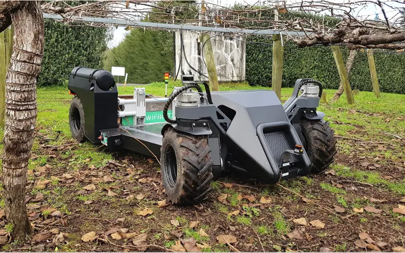
Autonomous Platform Development
The multi-purpose platform served as a mobile base for harvesting and pollinating systems. This hybrid petrol-electric vehicle achieved autonomous row-following using LiDAR-based orchard structure sensing. Six electric motor/gearbox units provided full electric drive capability while supplying AC and DC power to mounted systems. The platform supported 1 tonne payload capacity with additional fruit storage between rear wheels.
Harvesting System
The harvesting system identified kiwifruit in 3D space using stereo cameras and neural networks. It determined optimal picking sequences to minimize damage to neighboring fruit before directing robotic arms to collect fruit. The integrated approach combined computer vision, machine learning, and precision robotics for orchard operations.
Pollination System
The pollination system used the same camera and neural network infrastructure to identify flowers in 3D space. It calculated pollen solution trajectory timing to account for vehicle motion, ensuring accurate flower targeting while driving. The system enabled autonomous pollination operations across orchard rows.
Education
I hold a PhD in electronic engineering from the University of Waikato (2011-2015); my thesis covered the electrical properties of interfacial double layers. Before that, a Master of Engineering with first-class honours (2009) and a Bachelor of Science in electronics and mechatronics (2005-2008).
Selected Publications
- Mark Hedley Jones, Jamie Bell, Daniel Dredge, Matthew Seabright, Alistair Scarfe, Mike Duke, Bruce MacDonald (2019). Design and Testing of a Heavy-Duty Platform for Autonomous Navigation in Kiwifruit Orchards. Biosystems Engineering
- Henry Williams, Canaan Ting, Mahla Nejati, Mark Hedley Jones, Nicky Penhall, JongYoon Lim, Matthew Seabright, Jamie Bell, Ho Seok Ahn, Alistair Scarfe, Mike Duke, and Bruce MacDonald (2019). Improvements to and large-scale evaluation of a robotic kiwifruit harvester. Journal of Field Robotics
- Jones, M. H., & Scott, J. B. (2014). Scaling of Electrode-Electrolyte Interface Model Parameters in Phosphate Buffered Saline. IEEE Transactions on Biomedical Circuits and Systems, 9(3), 441-448
Open Source & Tools
- Container-Magic: reproducible containerised development environments (my active flagship tool).
- Cartographer SLAM Trajectory Editor: a browser tool for hand-fixing misaligned submaps and re-optimising Cartographer pose graphs.
- dmenu-extended: an extensible launcher menu for Linux.
- Blender PCD I/O: point-cloud import/export for Blender.
- Calibration checkerboards: print-ready targets, widely used in robotics and computer vision.
Curriculum Vitae